Tourism in Jammu and Kashmir

About Jammu and Kashmir:
Jammu and Kashmir, is known as heaven on earth. In the seventeenth century the Mughal emperor Jahangir set his eyes on the valley of Kashmir. He said that if paradise is anywhere on the earth, it is here,while living in a houseboat on the mesmerizing Dal Lake."Gar firdaus,ruhe zamin ast, hamin asto, hamin asto, hamin ast." If there is ever a heaven on earth, its here, its here, its here. In Jammu and Kashmir the most important tourist places are Kashmir, Srinagar, the Mughal Gardens, Gulmarg, Pahalgam, Jammu, and Ladakh.
In Kashmir Valley:

Srinagar:
Srinagar is the capital of the northernmost Indian state of Jammu and Kashmir. It is situated in Kashmir Valley and lies on the banks of the Jhelum River, a tributary of the Indus. While not the largest, it is one of the biggest cities in India without a Hindu majority.The city is famous for its gardens, lakes and houseboats. It is also known for traditional Kashmiri handicrafts and dry fruits. It is also the headquarters of Srinagar district.

Dal Lake:
Dal Lake is a lake in Srinagar, the summer capital of the northernmost Indian state of Jammu and Kashmir. The urban lake, which is the second largest in the state, is integral to tourism and recreation in Kashmir and is nicknamed the "Jewel in the crown of Kashmir" or "Srinagar's Jewel".The lake is also an important source for commercial operations in fishing and water plant harvesting.

season, the temperature sometimes reaches −11 °C (12 °F), freezing the lake.


Manasbal Lake:
Manasbal Lake is located in the Jhelum valley, north of Srinagar city in the State of Jammu and Kashmir in India. The name Manasbal is said to be a derivative of the Lake Manasarovar. Lake is encircled by three villages viz., Jarokbal, Kondabal (also called Kiln place, is situated on the north-eastern side of the lake) and Ganderbal and is stated to be the deepest lake (at 13 m/43 ft depth) in the Kashmir valley. The large growth of lotus (Nelumbo nucifera) at the periphery of the lake (blooms during July and August) adds to the beauty of the clear waters of the lake. The Mughal garden, called the Garoka, (meaning bay window) built by Nur Jahan overlooks the lake.


Shalimar Gardens:
Shalimar Bagh is a Mughal garden linked through a channel to the northeast of Dal Lake, on its right bank located at 34.149°N 74.873°E near Srinagar city in the Jammu and Kashmir. Its other names are Shalamar Garden, Shalamar Bagh, Farah Baksh and Faiz Baksh, and the other famous shore line garden in the vicinity is Nishat Bagh. The Bagh was built by Mughal Emperor Jahangir for his wife Nur Jahan, in 1619.The Bagh is considered the high point of Mughal horticulture. It is now
public park.

Hari Parbat:
Hari Parbat is a hill overlooking Srinagar, the largest city and summer capital of Jammu and Kashmir, India. It is the site of a Durrani fort, built in 1808. It has the famous Shakti Temple on the western Slope and Muslim shrines of Khwaja Makhdoom Sahib and Akhund Mullah Shah on the southern slope. On the southern side of the outer wall there is a Gurudwara, which commemorates the visit of Guru Hargobind.

Gulmarg:
Gulmarg is a town, a hill station and a notified area committee in Baramula district in the Indian state of Jammu and Kashmir.Gulmarg is located 52 km from Srinagar. It is located at 34.05°N 74.38°E.It has an average elevation of 2,690 m (8,825 ft).

varieties of flowers from here. Today Gulmarg is not merely a mountain resort of exceptional beauty- it also has the highest green golf course in the world, at an altitude of 2,650 m, and is the country's premier ski resort in the winter.

Pahalgam:
Pahalgam is a town and a notified area committee in Anantnag district in India's northernmost state of Jammu and Kashmir. It is a popular tourist destination, and every year, many tourists visit Pahalgam.

Sonamarg:
Sonmarg or Sonamarg is a town of Jammu and Kashmir state of India. Situated at 87 km from Srinagar, it is a popular tourist destination.
Sonamarg, at an altitude of 3,000 metres above sea level, 87 km north-east of Srinagar. The drive to Sonamargh is though yet another spectacular facet of country side in Kashmir, this time in Sindh Valley. The Sindh Valley is the largest tributary of the valley of Kashmir. It is upwards of sixty miles long, and valley and deep rock-girt gorge to open grassy meadow land and village-dotted slopes.


Amarnath Temple:
Located in the Indian state of Jammu and Kashmir and situated on Mount Amarnath, the Amarnath caves are one of the most famous shrines in Hinduism. Dedicated to the god Shiva, the shrine is said to be over 5,000 years old. The shrine forms an important part of Hinduism.
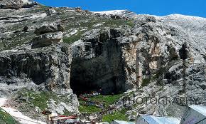
The cave is situated at an altitude of 3,888 m (12,756 ft), about 141 km (88 mi) from Srinagar, the capital of Jammu and Kashmir. The Central Reserve Police Force, Indian Army and Indian Paramilitary Forces maintain a strong presence in the region due to security concerns.
In Jammu:

Vaishno Devi:
Vaishno Devi Mandir is one of the holy Hindu temples dedicated to Shakti, located in the hills of Vaishno Devi, Jammu and Kashmir, India. In Hinduism, Vaishno Devi, also known as Mata Rani and Vaishnavi, is a manifestation of the Mother Goddess.


Poonch:
Poonch is a town and a municipal committee in Poonch District in the Indian state of Jammu and Kashmir. Based on the Mahābhārata evidence, and the evidence from 7th Chinese traveler Xuanzang, the districts of Poonch along with Rajauri and Abhisara had been under the sway of the Republican Kambojas during epic times.

Patnitop:
atnitop or Patni Top, is a hill top tourist location in Udhampur district, in Jammu and Kashmir, India, on the National Highway 1A, on the way from Udhampur to Srinagar, 112 km from Jammu. Situated on a plateau in the Shiwalik belt of the Himalayas, Patnitop sits at an altitude of 2024 metres. The river Chenab flows in close proximity to this location.


Sanasar:
Sanasar is the name given to the two small villages of Sana and Sar in Jammu province, India.


Bhimgarh Fort:
Bhimgarh Fort generally known as the Reasi Fort, near Reasi, a town approximately 64 km north-west of Jammu. The Fort is located on a hillock approx 150 metres high. Initially the Fort was constructed of clay and later on one of the heirs of Maharaj Rishipal Rana, the founder of Reasi, reconstructed it using stone. It was used by the royal family members for taking shelter during emergencies.

The Fort has a temple, a pond, a number of rooms of different sizes, armoury and treasury. After the death of Maharaja Gulab Singh, his heir Maharaja Ranbir Singh and Maharaja Pratap Singh used Bhimgarh Fort as a treasury and armoury. It was during Maharaja Hari Singh's rule that an English Minister ordered that the armoury be destroyed and shifted the treasury to Jammu.
The Fort was handed over to the Jammu and Kashmir State Archaeology Department in 1989 on the orders of state government. In 1990, the fort was renovated by the Vaishno Devi Sthapna Board. The surrounding areas of the fort were given a facelift with the construction of gardens and pathways. The fort was then opened to the public. Today the fort stands out as an important landmark in the town.
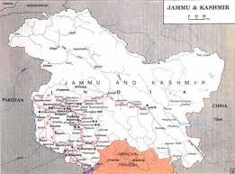
Map of Jammu and Kashmir:


Pictures of Jammu and Kashmir:


